South Klamath Hills
Overview
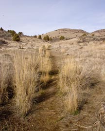
From a distance – even a close distance, the South (or Lower) Klamath Hills don’t look like much. Just a brown stretch of hills that rise abruptly from the floor of the Upper Klamath Basin. Grass, sagebrush and the occasional juniper tree dot the landscape – an ecosystem the experts call “sagebrush steppe.” On closer inspection hidden valleys, outstanding viewpoints, ancient history and tiny reflections of daily changes emerge. The lack of vegetation associated with relatively frequent wildfires exposes the contortions wrought during the volcanic creation of the hills. Wildlife including deer, antelope, quail and chukar frequent the area and attract hunters. You’ll also see various sorts of ground squirrels, lizards and snakes – including rattlesnakes. The area is closed to motorized vehicles, so our exploration will be on foot.
Access to the area is from a small, trail-head parking lot just off of Lower Lake Road at an elevation of 4,121 feet. The summit of the hills at 5,138 feet is a peak called Captain Jack. The peak is named after Captain Jack (aka Kintpuash) who was the leader of a group of Modoc Indians involved in the Modoc War of 1871.
History
The Klamath and Modoc Tribes have used this area for millennia. Prior to development of the Klamath Project, the farmlands to the west were what was known as Lower Klamath Lake. Villages and seasonal camps were probably established between the hills and the lake. Higher elevations were used for hunting and gathering. In an 1864 Treaty, the Klamath Tribes (Klamath, Modoc and Yahooskin) ceded this area to the United States. While the Tribes no longer have special rights in this area, they still hold concern for it as part of their traditional homeland. Please, as always, treat the land with respect.
After establishment of the Applegate Trail, which passes just south of the hills, and the arrival of settlers in the 1860-1870’s, the area became used for cattle ranching and agriculture.

Lady bugs spend the winter hidden under rocks at surprisingly high elevations. This colony is seeking the warming rays of the sun early in the spring.
A large segment of the Hills is publicly owned and managed by the U.S. Department of Interior, Bureau of Land Management. Everyone is welcome to visit and walk there and that’s the area this article addresses.
Exploring the South Klamath Hills
Given a full day a fairly energetic person could wander across most of the public portion of the hills. We visited the area three times for this article. First we tested our our GPS skills by finding a cache described below. On our second trip we followed the trail to its end then headed for the rocks near the top of Captain Jack. We planted our first cache on this trip. Finally we made a longer journey, to the far end of BLM land on the rim overlooking Jory Canyon. All three trips started at the trail-head parking area on Lower Lake Road.
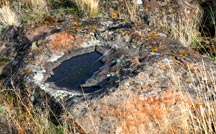
While the countryside seems barren, a little exploration says otherwise. The wide variety of ancient lichens growing on the rocks reveal the slow conversion of those rocks to soil. Little indentations on the rocks capture vestiges of the latest rain and provide sustenance to the small critters that live among them. Among those critters are tiny lady bugs that winter under rocks and emerge in the spring to absorb the warming rays of the sun. Cracks and crevices among the rocks offer shelter to mice, rats, rabbits and even coyotes. The rocks, upon close examination, are truly fascinating.

This aerial view of the Hills, looking north, reveals a volcanic crater that clearly blew out to the southeast.
Life can also be seen among the grass, sage and juniper that cover the area. The few large juniper trees make perfect tents for the deer that wander the hills. Insects from nowhere flock to a bird carcass to help it return to the earth from whence it came. The occasional raptor crosses the hills looking for the rodent that will be his next meal. Tiny lizards scamper among the rocks. Ground squirrels dash for their dens. An occasional rattlesnake coils under a rock while other snakes slither away at top speed.
From a distance, the Hills are clearly volcanic in origin. When there on foot, the contortions of the earth by those volcanic actions can sometimes be misleading. We climbed through the rocks rimming the ancient crater. After further research we realized that the crater could be easily circled to reach the summit of Captain Jack. The longer, but less strenuous climb, brought us to the peak where the views are stunning.
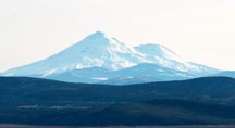
Mount Shasta can be seen 90 miles away toward the south and west, across the farmlands formed when the shallow Lower Klamath Lake was drained. While resting atop a volcano, a local hotspot for earthquakes and geothermal water, and looking at this sleeping giant on the horizon the sense of “the rim of fire” is palpable. To the west, the Cascade Mountains reach as far as the eye can see and to the north and east are the upper reaches of the great Klamath River watershed. Farmlands mosaic the middle view with their shades of green. The City of Klamath Falls fades in the distance. From this one vantage point you can easily see thousands of square miles of terrain ranging from the rugged Cascades to the smooth floor of the Upper Klamath Basin.
Below Captain Jack, to the east, is Jory Canyon. An old road travels up the canyon, over the divide and back down toward Lower Lake Road. Climbing to the top of the rim on the eastern side of Jory Canyon requires thoughtful planning and careful footwork. We walked up the trail from the trailhead then cross country to the Jory Canyon road, over the divide into Jory Canyon then cross country to the rim. On the way up we avoided rockfalls as much as possible, for better footing, and explored the small hanging valley east of Jory Canyon before climbing back up to the rim. Coming back down we noticed movement under a rock just below us. A brief inspection revealed part of a nervous snake with a clear diamond pattern on its back. Discretion being the better part of valor, we didn’t get close enough to check for rattles and instead bypassed the snake. When exploring this area, or any other area, for that matter, be aware of potential hazards and keep alert.
Geocache
There is a geocache up the trail aways from the trailhead. It is located here: N 42° 03.737 W 121° 45.168 Learn all about it at Pigeons, Pellets, and Shells. There is another cache farther up the trail, however the details on it are only available to premium members of geocaching.com. Look for GCP44M. The 2nd newest cache, placed by us, is located at N 42° 04.585 W 121° 45.754. For details see Captain Jack. The newest cache, also placed by us is located at N 42° 04.981 W 121° 45.226. For details see Jory View.
More Information
Get a Google Map of the area.
For more information on the Applegate Trail and its role in the history of this area, you may want to stop at the Landrum Historic Wayside on Highway 97 right at the state line.
The Volcanic Legacy Scenic Byway follows U.S. 97 in this area. A series of panoramic views associated with the byway include one from the top of Captain Jack.
The Oregon Welcome Center (11001 Highway 97 South – Milepost 282) at Midland is a few miles northwest of the South Klamath Hills. There you will find restrooms, beverages and lots of information.
Getting to the South Klamath Hills
There are three great ways to get to Klamath Falls, by air to the Klamath Falls Airport (via Portland, Oregon or San Francisco, California), by Amtrak (Coast Starlight Route) and by car. Once in the area, primary access to this area is off of U.S. 97 south of Klamath Falls. From U.S. 97 take Cross Road (just south of the Oregon Welcome Center at Midland) east to Lower Lake Road then Lower Lake Road south to the trailhead (on the left).
Rating
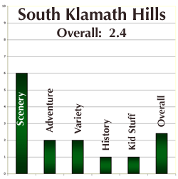
I rated this area fairly highly for the expansive views although much detail is lost in the distance and it takes a clear day for the full effect. While remenisent of the sagebrush country of the wild west, the area just isn’t remote enough to evoke the feeling of that western adventure. There is some variety at a very localized scale – the vegetation, the rocks, the volcanic landscape – but the element of water is most striking in its lack. At a somewhat larger scale the volcanic geology of the peak of Captain Jack, Jory Canyon and the hanging valley to the east of Jory Canyon allow for some great exploration. History surrounds the area, but the area itself offers no hint of that history, aside from the old road in Jory Canyon. Some kids will enjoy climbing on the rocks, seeking a geocache, or just running around, but there is little beyond that. Overall: 2.4 out of 10. It’s a great place to get out and poke around, but not a premier place like others that will be presented in these e-pages. What do you think? If you’ve explored this location, please offer your comments below.
Author
Jerry Haugen, Pathfinder
© 2010 Global Creations, All Rights Reserve


Leave a Reply