Long Range Traverse

Our friends on the forum at Camping Babble, have a thread called “Wanna” see YOUR magnificent trails… Participants are invited to post information and photos of their favorite trails. Recently @NorthernDancer highlighted the Long Range Traverse located in Newfoundland. The closest I’ve ever been to Newfoundland is the White Mountains of New Hampshire, but the description and photos certainly made this trek sound fascinating. I decided to see what I could learn about it. In this post, I’ll explain what I learned, how I uncovered the information and, in the process, share what I learned.
Finding the Basic Information
As usual, I started with Google. My search immediately returned the fact that the Long Range Traverse is located in Gros Morne National Park. The Park’s website provided all the basic information, but, alas no map. The site does offer a short explanation.
The Long Range Traverse is known across Canada for its challenge and beauty. Reaching 800 metres out of the bogs along the Atlantic coast, the ancient Long Range Mountains mark the north end of the Appalachian mountain range. The arctic-alpine bogs and barrens are home to caribou, moose, arctic hare, and black bear
The Long Range Traverse is an unmarked route that connects the eastern end of Western Brook Pond to the Gros Morne Mountain hiking trail. To reach the gorge at the end of the pond, hikers must complete the North Rim Traverse or take the Western Brook Pond boat tour. Tickets are required and the boat runs from mid-June to October. A series of primitive campsites serves as waypoints.
– Parks Canada
From there, the website explains that reservations are required and only three groups of up to four people each are allowed to enter the trail each day. Dates can be reserved, starting February 1, for dates between June 15 and September 30. The site then describes the trail and provides the location of each camping area along the way.
Getting Coordinates
The camping areas and key landmarks along the way are described and coordinates are also provided by Parks Canada. The problem: the coordinates are in “Universal Transverse Mercator” UTM (Zone U21 Datum NAD 83) coordinates. Most GPS units aren’t very good with coordinates like this, so I started looking for ways to make the conversation to the latitude and longitude system used by most GPS units (WGS84/NAD 83).
 I found several conversion programs that run on the web, but none of them would convert the Universal Transverse Mercator system in Zone U21. It then occurred to me that our old friend Google Earth can display various coordinate systems. Sure enough, it can display the UTM system, but it wasn’t exactly clear how one would would input the UTM coordinates to get the GPS coordinates.
Parks Canada supplies coordinates like this: 21U 452380m E / 5507076m N These indicate the distance in meters north and east of a point that is 500,000 meters west of the central meridian of the zone. The whole Universal Transverse Mercator system can get pretty complicated. If you’d like to learn more about it, Wikipedia has a good article and Garmin offers a discussion about various coordinate systems and the GPS coordinates we often talk about.
For our purposes, I just needed to find a way to give Google Earth the coordinates so it could locate the point on the surface of the earth. By leaving Google Earth set to display GPS coordinates, I could quickly get the GPS coordinates and check the map to see if it matched the description provided by Parks Canada. It took several searches with Google to discover that if I entered the coordinates like this: 21 U 452380 5507076 Google Earth could find the point and display its GPS coordinates. With reference to the points mentioned on the Gros Morne website I was able to gather this information:
| Description | UTM Coordinates | GPS Coordinates | Elevation (Feet) |
| Western Brook Pond | 21 U 452380 5507076 | 49° 42.858’N 57° 39.633’W | 78 |
| Waterfall | 21 U 454800 5506121 | 49° 42.339’N 57° 37.576’W | 833 |
| Top of Western Brook Pond Gorge |
21 U 455782 5506005 | 49° 42.296’N 57° 36.795’W | 1878 |
| Little Island Pond | 21 U 455426 5503813 | 49° 41.111’N 57° 37.076’W | 1724 |
| West side of Mark’s Pond |
21 U 454721 5501255 | 49° 39.728’N 57° 37.645’W | 1645 |
| Notch Past Mark’s Pond |
21 U 454718 5499677 | 49° 38.876’N 57° 37.636’W | 2017 |
| Harding’s Pond | 21 U 453863 5497462 | 49° 37.677’N 57° 38.311’W | 1555 |
| North of Green Island Pond |
21 U 448869 5494669 | 49° 36.146’N 57° 42.458’W | 1965 |
| Approach to Ferry Gulch |
21 U 444602 5493695 | 49° 35.598’N 57° 45.993’W | 2163 |
| Ferry Gulch | 21 U 444338 5493808 | 49° 35.657’N 57° 46.213’W | 1792 |
That’s enough to enter coordinates in your GPS before you set off on this expedition.
Traveling with Google Earth
As I was messing around with Google Earth, I marked each of the above points. I then saved a copy of the resulting view that looks like this (click for a larger, readable version):

Given the information provided by Parks Canada and a depiction of waypoints along the trail we can get a really good idea of the adventure. First of all, the trail isn’t much of a trail. It looks like much of it is on rock and hikers don’t usually follow the same path. Thus, some pieces may look like a trail and other pieces will not. Be prepared for a cross-country adventure. From what I can tell, there aren’t many large trees after you make it to the top of Western Brook Pond Gorge. This could be a very hot summer hike. There are lots of ponds to pick up drinking water along the way, but I suspect they harbor an impressive number of mosquitos. It also looks like there are a lot of bogs and marshes to cross or avoid,
Most people apparently take a boat to the starting point of the trail at the east end of Western Brook Pond. From there the trail climbs 1,800 feet to the top of Western Brook Pond Ridge. Along the way, you will come upon a waterfall that drops several hundred feet down the ridge. Parks Canada says to follow the brook from the bottom, crossing it as necessary then stay to the south of the waterfall to climb the ridge. From Google Earth, the distance from the pond to the waterfall is about 1.7 miles and from there another 0.7 miles (and a 1,000 foot climb) to the top of the ridge. From there it’s another 1.6 miles to the campsite at Little Island Pond. According to Parks Canada that 4 mile hike will take around six hours.
I plotted a path from Little Island Pond along the pond and creek to the campsite on the west side of Mark’s Pond. Google Earth says it’s around 2 miles. It’s another 1.2 miles to the notch and another 1.6 miles to the campsite at Harding’s Pond. I get around 4 miles from Harding’s Pond to Green Island Pond although the terrain is such that it is hard to pick a decent path from Google Earth.
From Green Island Pond it’s around 3.5 miles to the ridge above Ferry Gulch and something like 1/4 mile and a 370 foot drop into Ferry Gulch. That’s where the trail ends, but it leaves one in the middle of nowhere at the Gros Morne Mountain trail. The quickest way out from there is along the Gros Morne Mountain Trail down Ferry Gulch to a parking area on Highway 430, a little over 3.5 miles away. The following Parks Canada map of the Gros Mountain Trail will give you an idea of the situation. The primitive Campsite is where the Long Range Traverse ends.

Topographic Map
Natural Resources Canada offers free, downloadable topographic maps much like the U.S. Geological Survey. I found it very difficult to find the map that covers this area. After much experimenting, I found the map on Canada’s Toporama, a part of GeoGratis, and downloaded the TIFF format (a 15.45MB zip file that expands to 48.6 MB). The version shown below is in jpeg format. If you click on it you will see a larger version (2.7. MB) that you can download or open in a new browser window to see the full size version.
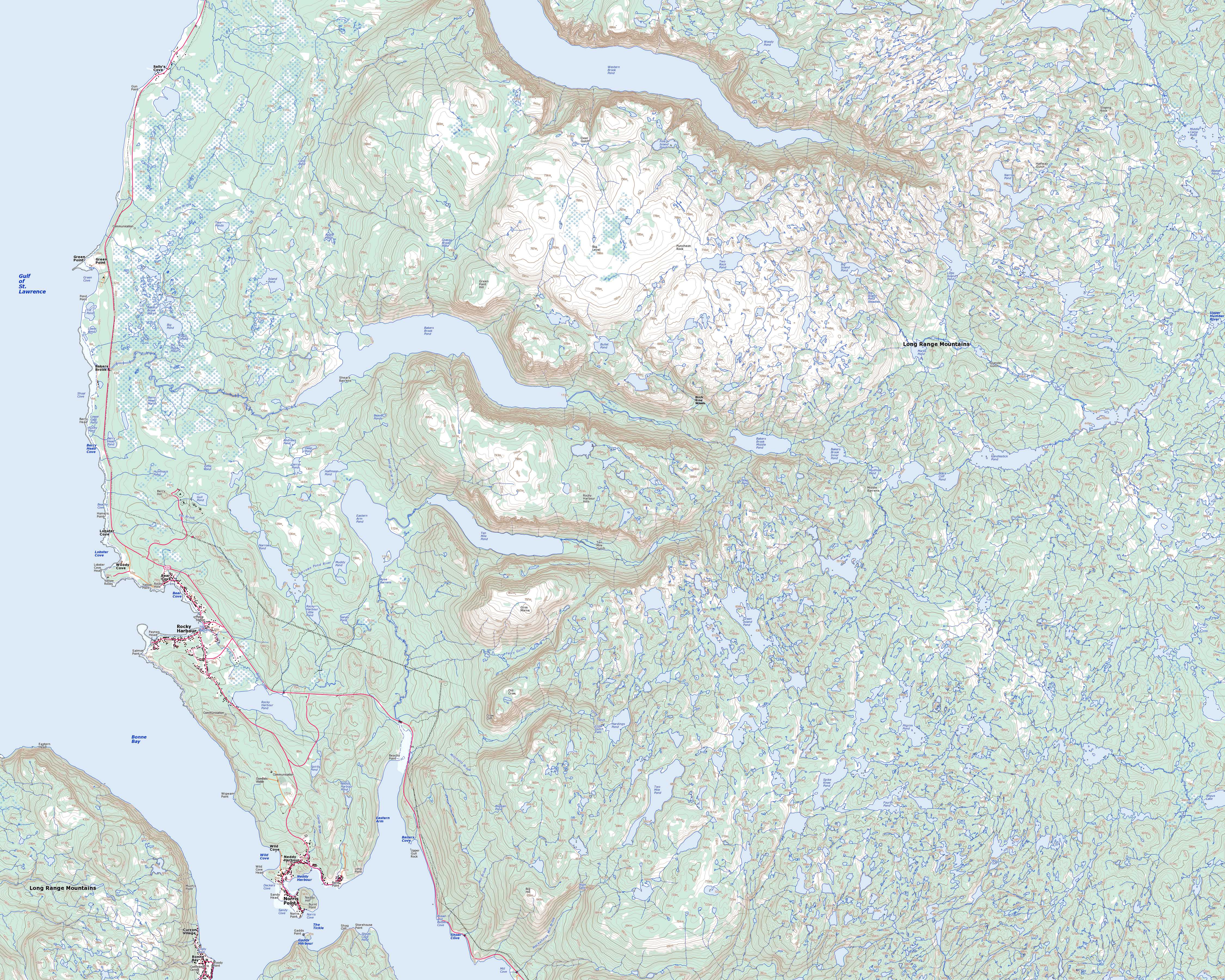
It’s a great map with a lot of detail. Unfortunately it doesn’t show any trails.
Don’t Forget YouTube
Conclusion
So there you have a way to learn more about a trail that is totally unfamiliar to you. With Google Earth and YouTube (or Vimeo), you can even get a good idea of what you would encounter along the way. This certainly doesn’t match the experience of actually hiking the trail, but it does offer a vicarious experience and most of the planning you need if want to actually get out there and explore. For a great first-person story by Tony Robinson-Smith, check out the Perceptive Travel website.
Credits
- Header Photo – Paul Gierszewski (Own work) [CC BY-SA 3.0], via Wikimedia Commons
- Gros Moren Mountain Map – Parks Canada
- Topographic Map – Natural Resources Canada
- Video – Justin Wellman
.jpg)
One Response to “Long Range Traverse”
Leave a Reply to Elizabeth Cancel reply
Great Products From Great Merchants
Recent Posts
Get Blog Posts by eMail
Deals of the Day – Don’t wait!
Gear Up!
Become a Patron

About Our Merchant Sponsors
![]() Subscribe | Follow Us:
Subscribe | Follow Us: ![]()
![]() | Share:
| Share: ![]()
![]()
![]()
Add this post to your Flipboard Magazine: Add to Flipboard Magazine.
Watch Our Video Podcast Series on iTunes or see our videos on YouTube.
Privacy Policy - Privacy Tools - Terms and Conditions - Copyright and Trademark Statement
©2018 Global Creations LLC - All Rights Reserved.
I just wanted to say thank you for posting this. I am sitting in the deer lake airport right now trying to punch these coordinates into my backup gps unit. I couldn’t figure out how to do so with the UTM. This info saved the day. Thank you!