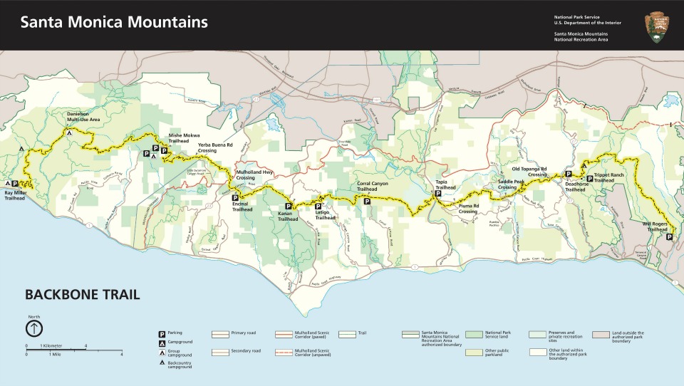
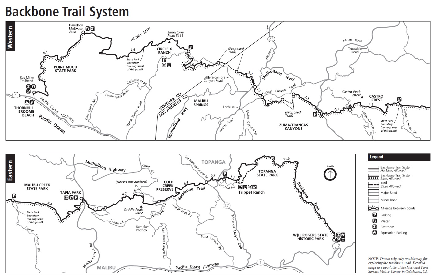
Backbone Trail

The Backbone Trail opened officially today, June 4, 2016. The trail begins at Thornhill Broome Beach in Point Mugu State Park on the coast just west of Malibu, California. It extends 67 miles up, into and through the length of the Santa Monica Mountains to Will Rogers State Historic Park near Santa Monica, California.
Decades of Development
![View of the ocean from Circle XRanch [NPS Photo]](https://explore.globalcreations.com/theblog/wp-content/uploads/2016/06/View-of-the-ocean-from-Circle-X-RanchNPS.jpg) The trail has been under development for decades, with work beginning in the 1980’s. Not only is trail construction challenging in the rugged terrain, but the trail passes through a variety of ownerships. A partnership between the National Park Service, responsible for the Santa Monica Mountains National Recreation Area, and the California Department of Parks and Recreation, responsible for state parks along the way, was instrumental in developing the route and working closely with private landowners to make the complete trail a reality.
The trail has been under development for decades, with work beginning in the 1980’s. Not only is trail construction challenging in the rugged terrain, but the trail passes through a variety of ownerships. A partnership between the National Park Service, responsible for the Santa Monica Mountains National Recreation Area, and the California Department of Parks and Recreation, responsible for state parks along the way, was instrumental in developing the route and working closely with private landowners to make the complete trail a reality.
The public has acquired more than 180 parcels, valued in excess of $100 million, to complete the route. California State Parks owns more than 60% of these lands.Recently a 40-acre parcel of land in Zuma Canyon was donated by former Governor Arnold Schwarzenegger and fitness entrepreneur Betty Weider. The property, valued at more than $500,000, represents the single largest private donation for the Backbone Trail.
 Backbone Trail Conditions

The original idea to connect existing trails together resulted in trail conditions ranging from single-track trails to old fire roads. Further, various uses are limited on certain sections of the trail. Hikers are welcome anywhere on the trail, but mountain bikes, for example, may only use segments posted as open for that use.
The trail is unique in that it is a rugged wilderness experience, but always within a few miles of major urban areas. Some segments are even within the city limits of Los Angeles and Malibu. Part of the wilderness experience comes from the sage and chaparral ecosystems that offer only low brush and virtually no trees for shade. This will be a hot and dry hike most of the year. In addition the trail is a bit of a roller coaster with elevations ranging from the coast to the 3,111 ft (948 m) top of Sandstone Peak with drops and climbs into and out of canyons and from peak to peak throughout its length.
Hiking the Backbone Trail
If you are planning to hike the trail, be aware that camping along the trail is limited. There are a number of campgrounds close to the trail, but it is often difficult to get reservations to use them. Efforts are underway to provide campsites along the trail itself for through hikers. In the meantime, there are many trailheads with parking that make series of day hikes practical.
Maps
More information
![On the Backbone Trail [National Park Service Photo]](https://explore.globalcreations.com/theblog/wp-content/uploads/2016/06/backbones.jpg)
Please Share
Great Products From Great Merchants
Recent Posts
Get Blog Posts by eMail
Deals of the Day – Don’t wait!
Gear Up!
Become a Patron

About Our Merchant Sponsors
![]() Subscribe | Follow Us:
Subscribe | Follow Us: ![]()
![]() | Share:
| Share: ![]()
![]()
![]()
Add this post to your Flipboard Magazine: Add to Flipboard Magazine.
Watch Our Video Podcast Series on iTunes or see our videos on YouTube.
Privacy Policy - Privacy Tools - Terms and Conditions - Copyright and Trademark Statement
©2018 Global Creations LLC - All Rights Reserved.
Leave a Reply