Beneath the Deep Blue

To do their thing, explorers first learn everything they can from those that have come before. Several years ago the U.S. Geological Survey (USGS) delivered some results from their explorations that gave us more to know about Crater Lake, located in Crater Lake National Park, Oregon, the deepest lake in the United States. A lake once believed to be bottomless.
Mapping the Bottom of Crater Lake
They mapped the bottom of the lake using a high-resolution multi beam echo sounder. A map of a lake or ocean bottom is called a bathymetric map and the survey work used to produce the map is called a bathymetric survey. This bathymetric survey provides a 2 meter per pixel view of the lake floor from its deepest basins to the shoreline.
Understanding the Data
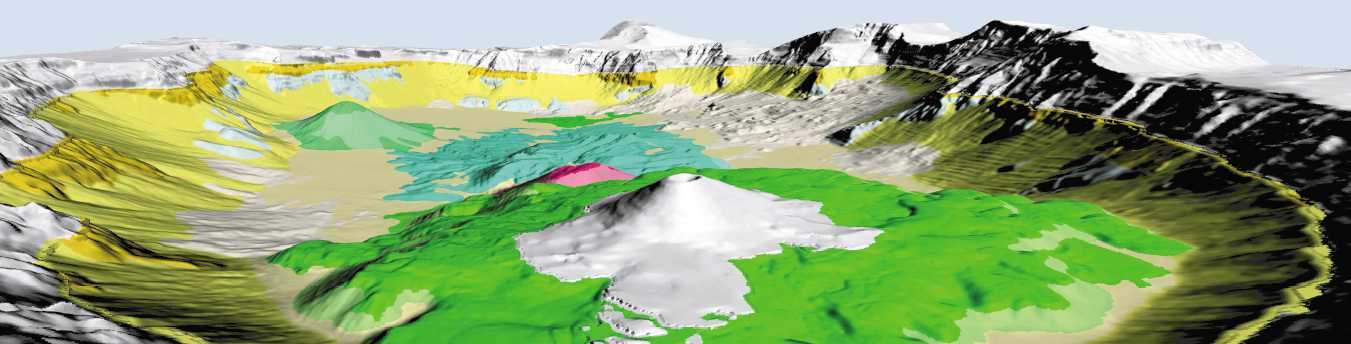
Using the survey data and information about the geology of the area, researchers created the above bathymetric map. On it we can see some interesting things.
First, we’ve always known that the rocks making up the Phantom Ship are some of the oldest in the lake area. Here we can see that rocks of a similar age are scattered around the lake near the shoreline. These are the rocks shown in a dark yellow and labeled “maz.” These rocks were part of Mt. Mazama before it blew.
Second, and not surprisingly, even older rocks are found beneath the “maz” rocks. These are shown in a pale blue and labeled “pmu.” The rocks were there before Mt. Manama formed on top of them.
Third, besides the small parts of the lake bed made of the above rocks, there are really only two types of geologic material on the lake bed: rocks and other materials that found their way into the lake as the sides of the caldera slid and eroded into it (white and lighter shades of yellow) and newer rocks created from volcanic activity that occurred in the caldera after the mountain blew its top (greens and reds).
Fourth, we can see the terrain of the lake bottom. Thanks to the way the data was collected, it can be manipulated using geographic information systems to give us an infinite variety of views. The view shown below is as if you were standing at the visitors overlook at The Watchman. Click the image to see a larger version.
Using the Results
Just like an explorer using a map made by someone else, future exporters of Crater Lake will use the information developed here to plan their expeditions. Whether they want to investigate the oldest rocks or the new volcanic features under the lake, this information will help them focus their adventures to reveal more of the mysteries of Crater Lake.
More Information
For more information and to see the entire graphic from which the above elements were extracted see:
Ramsey, David W.; Dartnell, Peter; Bacon, Charles R.; Robinson, Joel E.; Gardner, James V., 2001, Crater Lake revealed: U.S. Geological Survey Geologic Investigations Series Map I-2790, 1 plate, https://pubs.usgs.gov/imap/2790/.
Please Share
Great Products From Great Merchants
Recent Posts
Get Blog Posts by eMail
Deals of the Day – Don’t wait!
Crater Lake
Gear Up!
Become a Patron

About Our Merchant Sponsors
![]() Subscribe | Follow Us:
Subscribe | Follow Us: ![]()
![]() | Share:
| Share: ![]()
![]()
![]()
Add this post to your Flipboard Magazine: Add to Flipboard Magazine.
Watch Our Video Podcast Series on iTunes or see our videos on YouTube.
Privacy Policy - Privacy Tools - Terms and Conditions - Copyright and Trademark Statement
©2018 Global Creations LLC - All Rights Reserved.
Leave a Reply